

Wedgemount Glacier Monitoring: Recession continues in 2025
- Nov 21, 2025
- 2 min read

The 52nd annual survey took place in late August this year. Volunteers with the Whistler Naturalists, led by Rob Tupper, repeated the photogrammetric mapping done by BCIT Geomatics students in 2020. We now have a five-year surface-to-surface comparison of the glacier terminus and have created an updated digital orthophoto (a geometrically corrected aerial photo). In addition, we can compare the research from this year with BCIT’s GPS surveyed profile completed in 2012.
A summary of the initial 50 years of surveying the glacier was published in the 2024 edition of the Canadian Alpine Journal, and a copy is available in our local library. In those 50 years of traipsing up and down the steep trail to the lake, the horizontal recession of the glacier terminus was 700 metres, with only one year (1980/81) showing a slight advance of less than a metre!
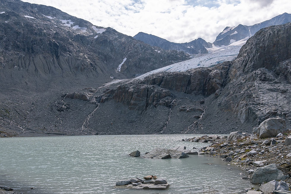
Survey methodologies varied over those five decades. It began with ground-based photogrammetry, which involved measuring recession using photos taken from the exact same position year after year, a technique employed while the glacier terminus was still located in Wedgemount Lake. Then, while the ice front was accessible over land, we recorded the recession using an old-fashioned tape measure between permanent cairns and the toe of the glacier. And when recession exposed a new Tupper Lake in the last two decades, we had to resort to triangulation from a measured baseline. However, above this new lake, recession continued beyond an imposing rock step, and so the use of high-precision GPS (2022-2024) and, finally, aerial photogrammetry in 2025.
The 2025 mapping shows the glacier receded 16.8 metres horizontally last year (to August 29, 2025) and provided an exact outline of the ice terminus, which is jagged in outline to say the least. Furthermore, the ice in the melt zone had thinned (or ablated) 2 to 5 metres over the year, with a 2025 to 2012 surface profile comparison showing an average thinning of 26 metres, supporting our surmise that what is now left of the glacier is living on borrowed time. Could the glacier melt away entirely up to the base of Wedge Mountain icefall in less than 100 years? The average recession over the first 50 years of our survey was 15 metres per year, and it has been accelerating each decade. So, stay alert and stay tuned.
This is Karl’s last Wedgemount report. At age 90, he will obviously not be part of that shrinking dictum. And so, he says it was fun while he was part of the action. Yes, a regime change; new investigators are now at the helm. Lead surveyor Rob Tupper is a professional surveyor at Monashee Surveying and Geomatics, and the son of Bill Tupper, who started Wedgemount Monitoring in 1973 as an instructor at BCIT. This ongoing research project is possible thanks to generous funding from the Whistler Community Foundation.
Written by: Karl Ricker and Rob Tupper
The article explains how Wedgemount Glacier continues to shrink, with monitoring in 2025 showing ongoing recession and ice loss. It highlights how long-term glacier studies help scientists understand climate change and its effects on water systems and local environments. I remember during a busy semester while studying environmental science and preparing for exams, I once searched do my online exam because I felt overwhelmed with deadlines. That experience taught me that staying organized and working steadily makes difficult challenges much easier to manage.
Before trusting any company with a large or technically demanding project, it’s important to evaluate both their technical expertise and their communication style. A website such as https://sharkscode.com/ can help you understand the general direction of the company, including their focus on backend systems and scalable solutions. However, websites only show the surface level. You should also speak directly with their engineers and project managers to understand how they approach architecture, deadlines, and problem-solving. Strong companies are usually transparent about their processes and can clearly explain how they manage performance, scalability, and reliability in real-world environments.
Visiting the graveyard on Shab-e-Barat is considered permissible if done with the intention of remembering the Hereafter and making dua for the deceased. Islam encourages reflection and supplication, but there is no obligation or special ritual fixed for this night. Therefore, those asking شب برات میں قبرستان جانا جائز ہے؟ should focus on sincere worship and avoid unverified practices.
The article comparing Phentermine and Semaglutide offers a thoughtful and thorough breakdown of two distinct approaches to weight loss. I appreciated how Valhalla Vitality explains why one approach may work better in certain scenarios than the other. The content doesn’t feel salesy or biased — instead, it focuses on helping readers make informed choices. The piece also lays out the importance of lifestyle and diet alongside medication for best outcomes. Very worth the read if you’re researching these tools.
https://valhallavitality.com/blog/phentermine-vs-semaglutide-which-is-best-for-weight-loss
yuyu